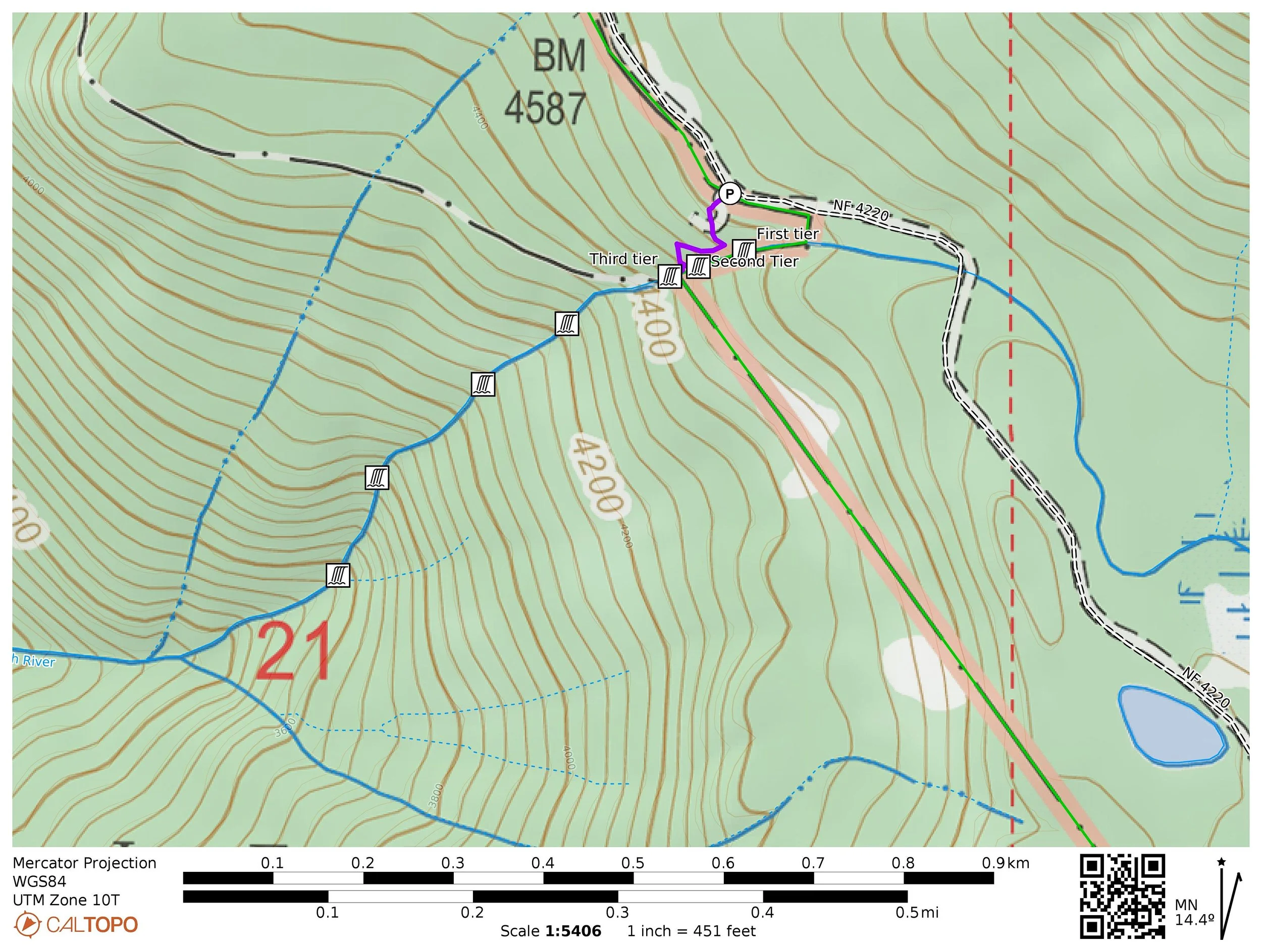
60. Breitenbush Cascades
Distance: 0.3 miles out and back
Elevation Gain: 150 feet
Trailhead elevation: 4,663 feet
Trail high point: 4,663 feet
Season: June - October
Best: June - October
Map: None needed.
Directions from Portland:
From Estacada, drive southeast on OR 224 approximately 25 miles to the Ripplebrook Guard Station.
A short distance after Ripplebrook, OR 224 becomes FR 46 at a junction with FR 57. Continue straight (right) on FR 46.
Drive another 22.3 miles on FR 46 to a junction with the Olallie Lake Road (FR 4690) – you will notice that “Olallie” is painted on the road with an arrow to mark the direction.
Continue past this junction 6.6 miles to a junction with the Skyline Road (FR 4220) on your left at Breitenbush Pass.
Turn left here and drive 1 mile of gravel road to a large gate.
Continue past the gate, where the road abruptly worsens into a rocky, narrow and severely rutted track that will test the patience of any passenger car driver to his or her breaking point.
Drive another 2.5 excruciatingly slow miles to the unsigned but obvious trailhead on your right.
If you cross the North Fork of the North Fork Breitenbush River, you’ve gone too far.
Directions from Salem:
From Salem, drive OR 22 east approximately 49 miles to Detroit.
Turn left at a sign for Breitenbush, Elk Lake and Olallie Lake onto FR 46.
Drive 16.6 miles on FR 46 to a pass where you enter the Mount Hood National Forest.
Turn right here on the Skyline Road (FR 4220) and drive 1 mile of gravel road to a large gate.
Continue past the gate, where the road abruptly worsens into a rocky, narrow and severely rutted track that will test the patience of any passenger car driver to his or her breaking point.
Drive another 2.5 excruciatingly slow miles to the unsigned but obvious trailhead on your right.
If you cross the North Fork of the North Fork Breitenbush River, you’ve gone too far.
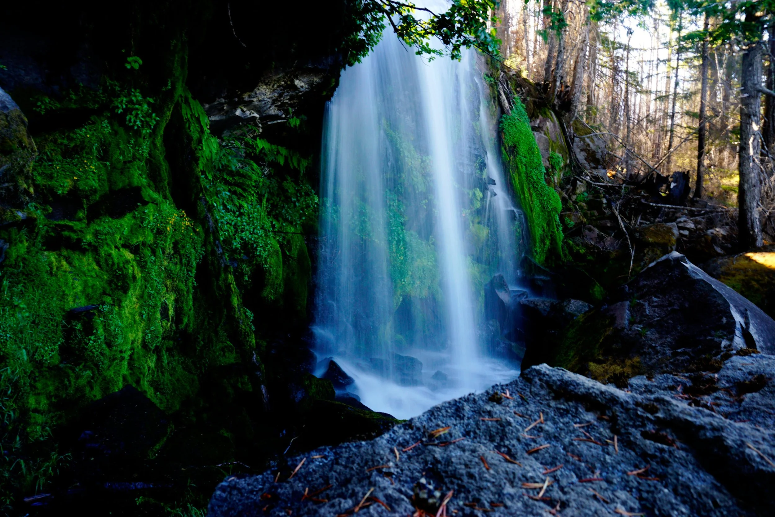
The second tier of Breitenbush Cascades, July 2023.
Hike: I’m going to tell you a secret: Breitenbush Cascades is one of Oregon’s tallest and best waterfalls. You probably haven’t heard of it, but standing next to this behemoth proves its greatness - you can stand at the precipice and look down and the many cascades below. There’s only one catch – it is virtually impossible to see the whole thing from any vantage point, so you’ll just have to use your imagination (or satellite imagery). Whether or not you believe me, this is a fantastic little hike that is worth a visit on your way to Breitenbush Lake, Ruddy Hill, Pyramid Butte or Park Ridge (Hikes 61, 62 and 63). This trail burned during the 2020 fires and is currently in rough shape, but still easy enough to follow. Exercise caution around the falls though, as it’s a long way down.
After navigating the Skyline Road, the Breitenbush Cascades will be a welcome relief. Descend three quick switchbacks, each passing the brink of a tier of the waterfall. On your way down look through the trees to a glimpse of Mount Jefferson, just six miles to the south. The first switchback is located at the very brink of the falls. At the second turn left for fifteen feet to a spot face-to-face with the highest tier of the falls, a twenty-foot veil of water. While this spot is nice, the next tier is even better.
You will switchback first to the right and back left towards the base of the second tier. When you reach the falls, use your hands and feet to carefully step over a large boulder at the edge of the narrow promontory inside the base of the second tier. Set in a mossy boulder garden, you’ll find yourself snapping pictures by the dozen. Be careful, however! The mossy rocks can be slippery and it is prudent to stay away from the lip of this tier of the falls as much as you possibly can. This is a very precarious spot and it must be respected.

Looking down the lip of Breitenbush Cascades, August 2020. This area would burn some three weeks later.
DO NOT attempt to continue downstream. Breitenbush Cascades drops approximately 1,200 feet over many tiers on its way to meet the South Fork of the North Fork Breitenbush River. The terrain here is extremely rocky, rough, steep, cliffy and treacherous. Once upon a time I tried to bushwhack down the side of the falls and nearly paid for the effort with my life. After getting cliffed out on a loose shale slope just above a cliff edge, I decided it was perhaps best to let Breitenbush Cascades remain the mystery it deserves to be. Do believe me when I say that this is an adventure best left to the birds. From the end of the trail, the best plan is to return the way you came.