Hike 67 - Tam McArthur Rim
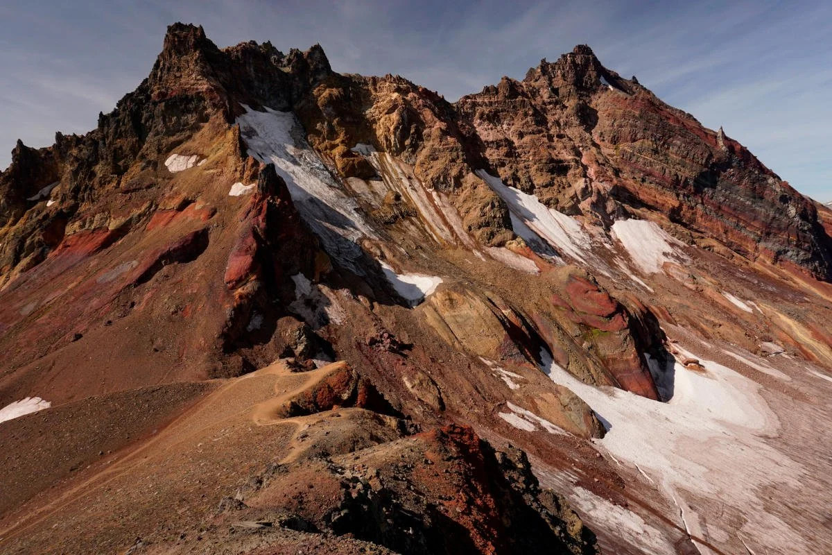
Broken Top from the end of Tam McArthur Rim.
Distance: 12.8 miles out and back
Elevation Gain: 2,500 feet
Trailhead Elevation: 6,527 feet
Trail High Point: 8,360 feet
Season: July - October
Best: July - October
Pass: NW Forest Pass + limited entry
On the traditional lands of: the Confederated Tribes of the Warm Springs
Directions:
From Sisters, drive Elm Street south, where it becomes Three Creek Road (FR 16).
Continue up this road for 14 miles of pavement and 1.5 miles of occasionally rough gravel road to a junction on your right for Driftwood Campground.
Turn right here and drive 100 bumpy feet to the trailhead parking lot on your right. The trail is across the main road on your left.
Drivetime from Sisters: 30 minutes
Hike: From Tam McArthur Rim the view seems to stretch on towards forever – but your eyes will be locked on Broken Top’s craggy summit directly ahead. This is one of Oregon’s best hikes, and with a lot of patience and energy, it can be truly unforgettable. Just make sure to pack sunscreen, enough water, and a windbreaker; the hike tops out at an elevation of over 8,000 feet, or higher than most of the mountains in the Oregon Cascades. With that in mind, you won’t regret a single step of this hike. Before you go, don’t forget to secure your day use or overnight permit; see the introduction to the Central Oregon Cascades on page 126 for more information.
Begin by climbing up above Three Creek Lake on a wide and well-maintained trail. Along the way you’ll have a few looks down to the lake, and out to the Three Sisters. At a little over a mile from the trailhead, the trail crests the lip of the rim and continues climbing gently towards the more open, higher part of the rim to the west. Before long you will find yourself at a junction with a horse trail that arrives from the south. Continue straight, passing a possibly unmarked junction with a trail that follows the edge of the rim more closely. However you decide to go, you will reach the official end of the Tam McArthur Rim Trail at 2.8 miles from the trailhead at a viewpoint known as The Prow. For less able hikers, this is an ideal turnaround spot. Here you will be standing at 7,700 feet above sea level, and more than 1,000 feet above both Three Creek and Little Three Creek Lake. Hikers with a fear of heights will want to stand well back of the rim edge, but there’s plenty of room to spread out here just the same. The view seems to stretch into infinity, with the Three Sisters looming across the fire-scarred canyons of Park and Whychus Creeks below. On very clear days you can see all the way to Mount Hood, and even Mount Adams in Washington.
If you’ve got more energy and are up for a more serious adventure, return to the main trail and soon pass a “Trail Not Maintained” sign (don’t fret, it’s in great shape). The eye-popping views of Broken Top and the Three Sisters get better with every step west. The unofficial trail continues gently uphill across a rolling ridgetop of red cinders for 2 more miles. The way is generally obvious and the trail wide and well-tread, but there are occasional spots that may necessitate a bit of route-finding. At 4.8 miles from the trailhead, you will climb to a saddle below Broken Hand’s cliffs. The views here are even better than they were at trail’s end, save for one thing: Broken Hand blocks most of the view west towards Broken Top. Hikers not skilled in the art of following faint, unofficial trails should declare victory here. On the other side of Broken Hand lies fabled No Name Lake, an aquamarine glacial tarn at the base of Broken Top’s summit glaciers. But getting there requires some ingenuity and persistence, if not dogged determination.
If you’re up for the challenge, you’ve got options. You can follow a faint trail to the left that descends into a scenic basin on the south side of Broken Hand. Should you lose this trail, you cannot possibly get lost as long as you follow the base of Broken Hand. From here, you can pick up user trails and continue until you hit the maintained trail to No Name Lake, not far from the lake. If you’d rather take the high route, you’ll have to follow the rough, exposed trail along the north side of Broken Hand. Neither of these trails are all that obvious, but they will all take you to No Name Lake in about a mile. The advantage of the high trail across Broken Hand is the views ahead to the lake. The high trail eventually drops to a narrow, exposed ridge perched between No Name Lake and the Bend Glacier on Broken Top’s north face. The views here are mind-blowing. From there, drop down to No Name Lake and fight the crowds for your pictures, and pat yourself on the back for getting to this special place the hard way. Most people hike to No Name Lake via the Broken Top Trailhead, a 6-mile round-trip hike that begins at the Broken Top Trailhead. This would be a great choice were it not for the absolutely horrendous access road. Most people you meet here won’t believe that you hiked here from Tam McArthur Rim, and you should feel free to tell them whatever horror story you’d like about the route. You’ve earned it. Camping is possible but banned within a quarter-mile of No-Name Lake. From wherever you ended up, return the way you came.
Map for Tam McArthur Rim.


