OWYHEE CANYONLANDS: LESLIE GULCH
Hike stats:
Distance of all trails: 5.8 miles out and back
Elevation Gain: 1,000 feet
Trailhead elevation: between 3,155 feet and 3,644 feet
Trail high point: 3,936 feet
Season: March – May, September – October
Best: March – May, September – October
Pass: none needed
On the traditional lands of: the Nüümü (Northern Paiute) people
Directions:
From wherever you live, make your way to the remote community of Jordan Valley, Oregon, just a few miles west of Oregon’s eastern border with Idaho. If you’re approaching this area from Ontario or Boise, you’ll need to drive south on US 95 from that area instead, skipping Jordan Valley.
Before you leave Jordan Valley, make sure you fill your gas tank and check your tire pressure. You’ll see plenty of people between Jordan Valley and Leslie Gulch but you should make sure you take care of any potential automobile issues before you leave town.
From the Sinclair station in Jordan Valley, drive north for 18 miles to a turnoff on the left signed for Succor Creek and Leslie Gulch.
Turn left and drive 8 gravel miles to a T-junction at the Rockville School. Turn left here.
Drive 1.7 miles to a turnoff on the left signed for Leslie Gulch.
Turn left and drive into the narrow, wildly scenic canyon of Leslie Gulch. You’ll reach the trailheads and destinations in the following order, with mileages from the last junction:
Dago Gulch: 9.3 miles
Juniper Gulch: 10.3 miles
Timber Gulch: 11.6 miles
Slocum Creek Campground: 13.8 miles
Lake Owyhee Reservoir boat ramp and roads end: 14.1 miles
Drivetime from Jordan Valley: 1 hour
Note: If thunderstorms or heavy rain are in the forecast, DO NOT plan on visiting Leslie Gulch. Heavy rain can turn the gravel road here to mud, washing out the road and leaving you stuck here until it dries out and somebody comes to fix the road.
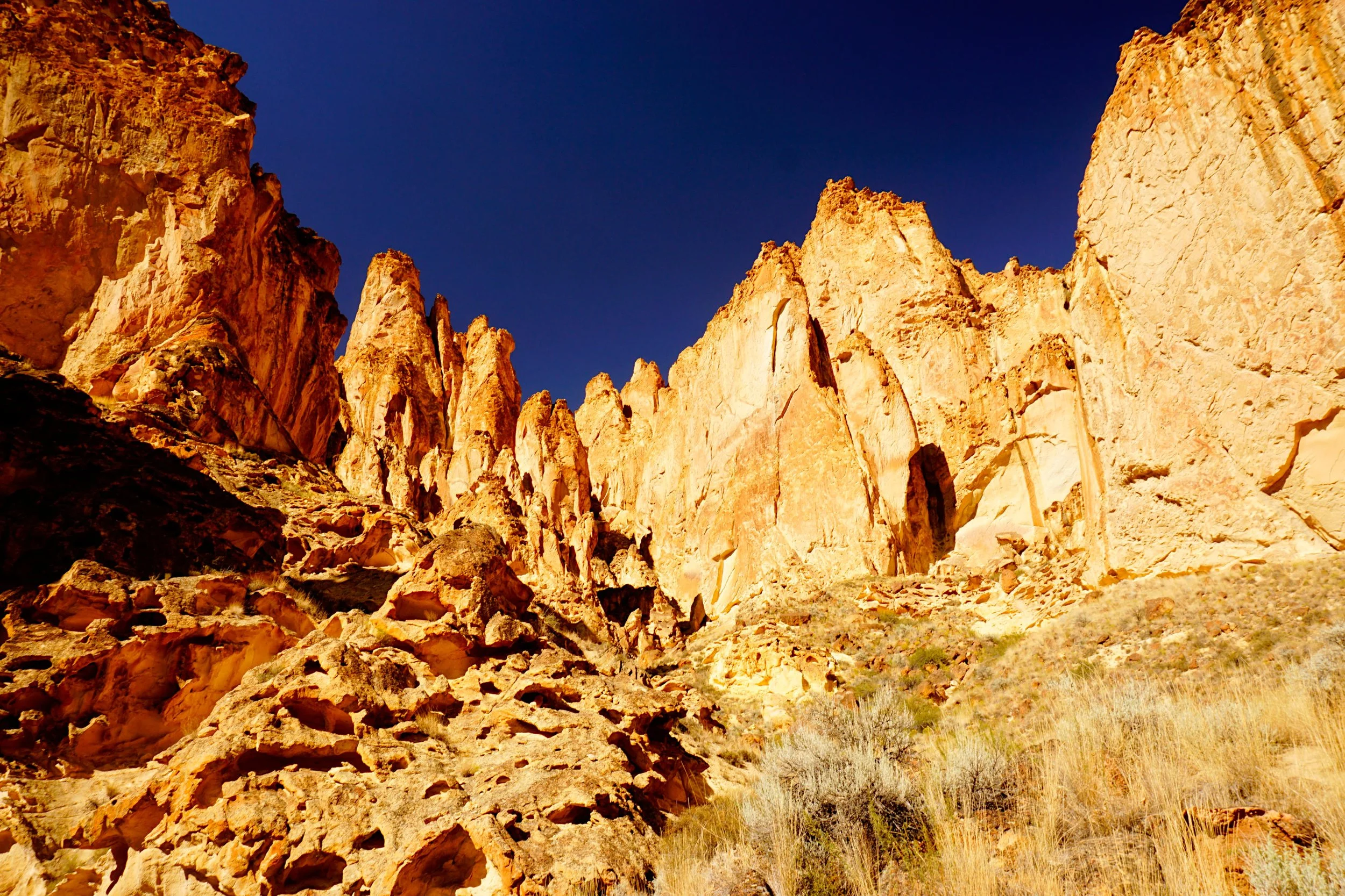
Hike: The Owyhee Canyonlands are truly one of Oregon’s most extraordinary places, and every Oregonian who loves the outdoors should plan on visiting at least once in their lives. It’s not easy, though. Most of this area is a true pain to visit; the roads are long and rocky dirt roads and turn to mud when it rains, rendering them undriveable. The remoteness of the area ensures that anyone who visits needs to take this place seriously, and plan for the worst even when the worst is unlikely. Anything is possible. Leslie Gulch, located on the northern end of this magical canyon, is the only place in the Owyhee Canyonlands that a hiker can visit with an average low-clearance vehicle. It takes a lot of effort to get there, but once you arrive you’ll be transported into the depths of this desert splendor. There are five major gulches in the Leslie Gulch area, and three of them make for good, short hikes. The order you hike them in does not matter, but they will be presented here in the order in which I hiked them.
Timber Gulch
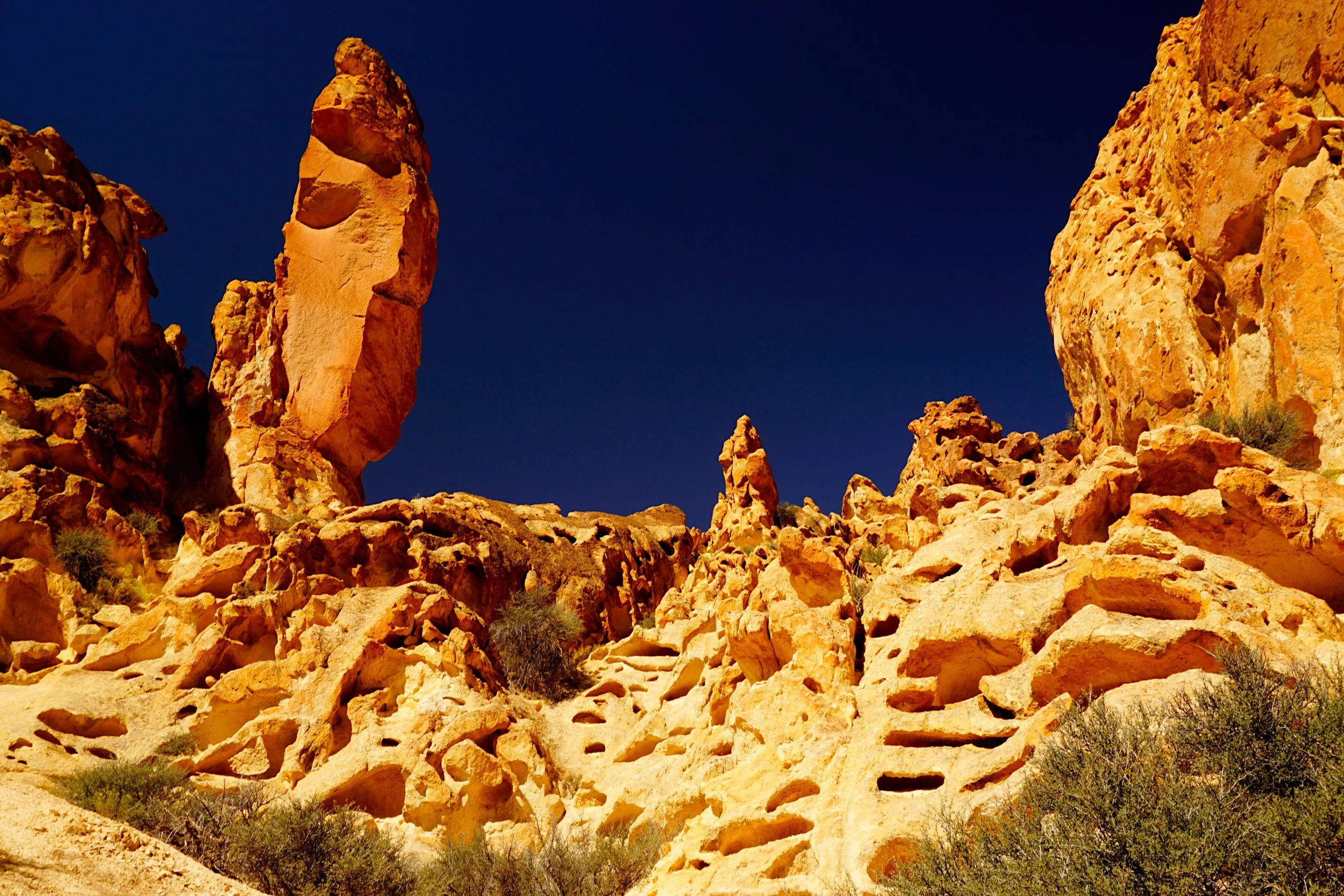
Juniper Gulch: From the Juniper Gulch Trailhead, locate the trail and follow it into the canyon. The trail is quite brushy, so you’ll want to make sure you’re wearing long pants. If you brought trekking poles (I never leave home without them), leave them in the car for this hike as you’ll want the use of your hands here. The trail enters a narrow canyon with red and orange rock walls several hundred feet high; you might think you fell asleep and woke up in one of Utah’s magical national parks! At 0.6 mile the canyon splits; left leads to an impassible slot canyon in just a few hundred feet, so instead turn right. The trail splits again in a few hundred yards, where you will head uphill to the right. In just a few minutes, Juniper Gulch’s impressive upper headwall comes into view. Continue on this faint trail to the headwall, a spectacular wall of sculpted pinnacles and honeycombed rock formations (see the photo on the next two pages). The trail peters out here but you can make a short loop by following the gully at the base of the honeycombs downhill until you reach the trail again. From here, return to the trailhead the way you came. One quick note about the pit toilet at the Juniper Gulch Trailhead: be on the lookout for black widow spiders in the bathroom, as they like to hide in the corner here. Eeek!
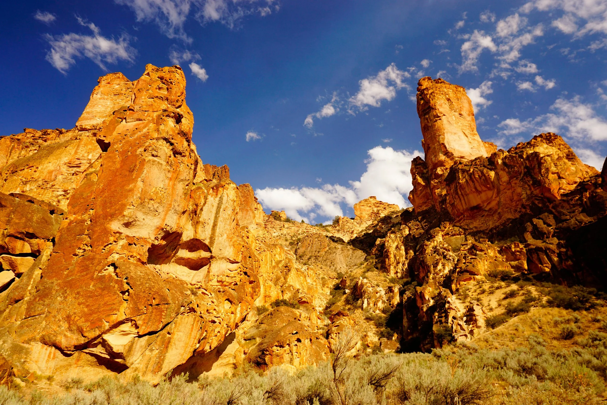
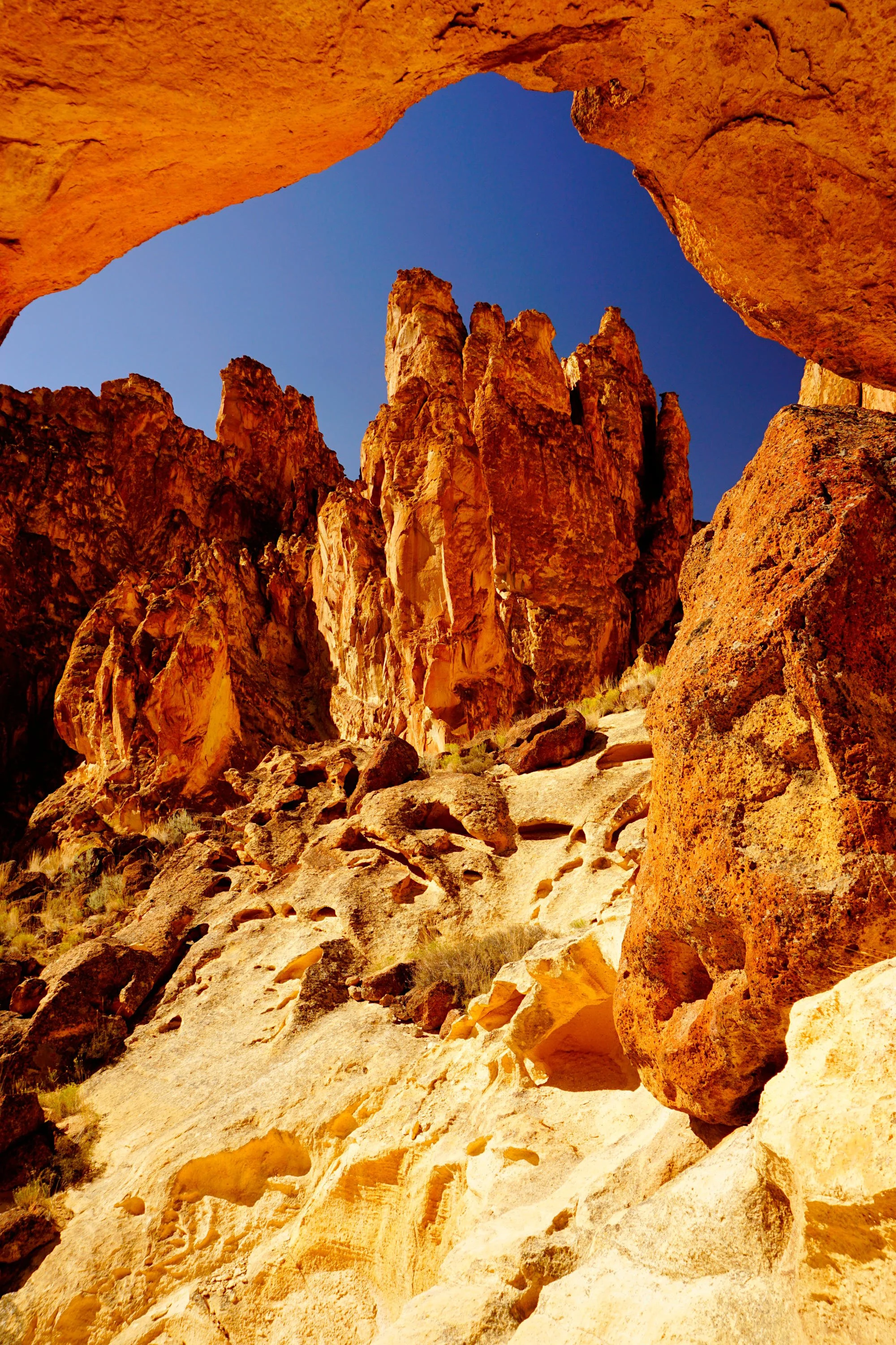
Timber Gulch: Just as with Juniper Gulch, this trail leads into a colorful amphitheater of naturally sculpted red and orange cliffs. Here though the cliffs are even more impressive and the canyon is even narrower than in Juniper Gulch; a more impressive place in southeast Oregon would be hard to find! From the unmarked trailhead, located at a pullout on the right side of the road 1.3 miles west of the Juniper Gulch Trailhead, locate the trail heading downhill into a wash. Follow the wash for a short distance until you reach the continuation on the trail on the left. Pick up the trail here and follow it through brush for 0.2 mile until you reach another trail junction on your right. Turn right here and follow this trail uphill into Timber Gulch’s northern amphitheater, which I nicknamed “The Temple” when I visited. At one point on your way up, look to your left to see a huge undercut rock fin that resembles a natural rock arch. The trail then follows the base of a huge cliff for a short distance before ending at the rocky base of this temple. If you love scrambling over boulders and climbing up draws you’ll love this spot, so leave yourself time to explore. Return the way you came.
Dago Gulch: This unfortunately-named canyon is quite scenic, but not as much as the first two gulches you visited. Furthermore, the views are better on the return trip and the canyon is quite shady in the afternoon; for these reasons, you should save Dago Gulch for the end of the day. From the trailhead turnaround, follow the road straight into the canyon. After scrambling over rocks and pushing through brush in the first two gulches you visited, the wide road proves a welcome change of pace. As with everywhere else in Leslie Gulch, colorful rock pinnacles tower over the canyon bottom. After 1 mile, you’ll reach a cattle gate and a “No Trespassing” sign, which is your clue to turn around. On your way back, take the time to savor the views back into Leslie Gulch’s inner sanctum. If you’re interested in staying down in this glorious canyon, camping is only permitted at Slocum Creek Campground near the end of the road.
