CRITERION RANCH
Exploring the old ranch roads in the Criterion Tract is immensely fun.
Criterion Ranch stats:
Distance: 11.6 miles out and back (or a 13 mile loop with an off-trail section)
Elevation Gain: 2,500 feet
Trailhead Elevation: 955 feet
Trail High Point: 2,720 feet
Season: All year (avoid summer heat)
Best: March – May
Pass: None needed
GPS Track: April 2024
On the traditional lands of: the Tenino and Warm Springs peoples
Directions:
From wherever you begin, make your way to the town of Maupin. Maupin is 45 minutes south of The Dalles on US 197, 2 hours southeast of Portland via Government Camp (or The Dalles), and 1 hour and 45 minutes north of Bend via US 97 and 197.
From downtown Maupin, cross the Deschutes River and turn right onto the Deschutes River Access Road. This junction will be on your left just before crossing the Deschutes if you’re coming from the south.
Once on this road, follow it for 3.6 miles of pavement and another 3.4 miles of good gravel to the trailhead at a locked gate. Along the way, you’ll pass a number of small but welcoming campgrounds should you wish to spend the night.
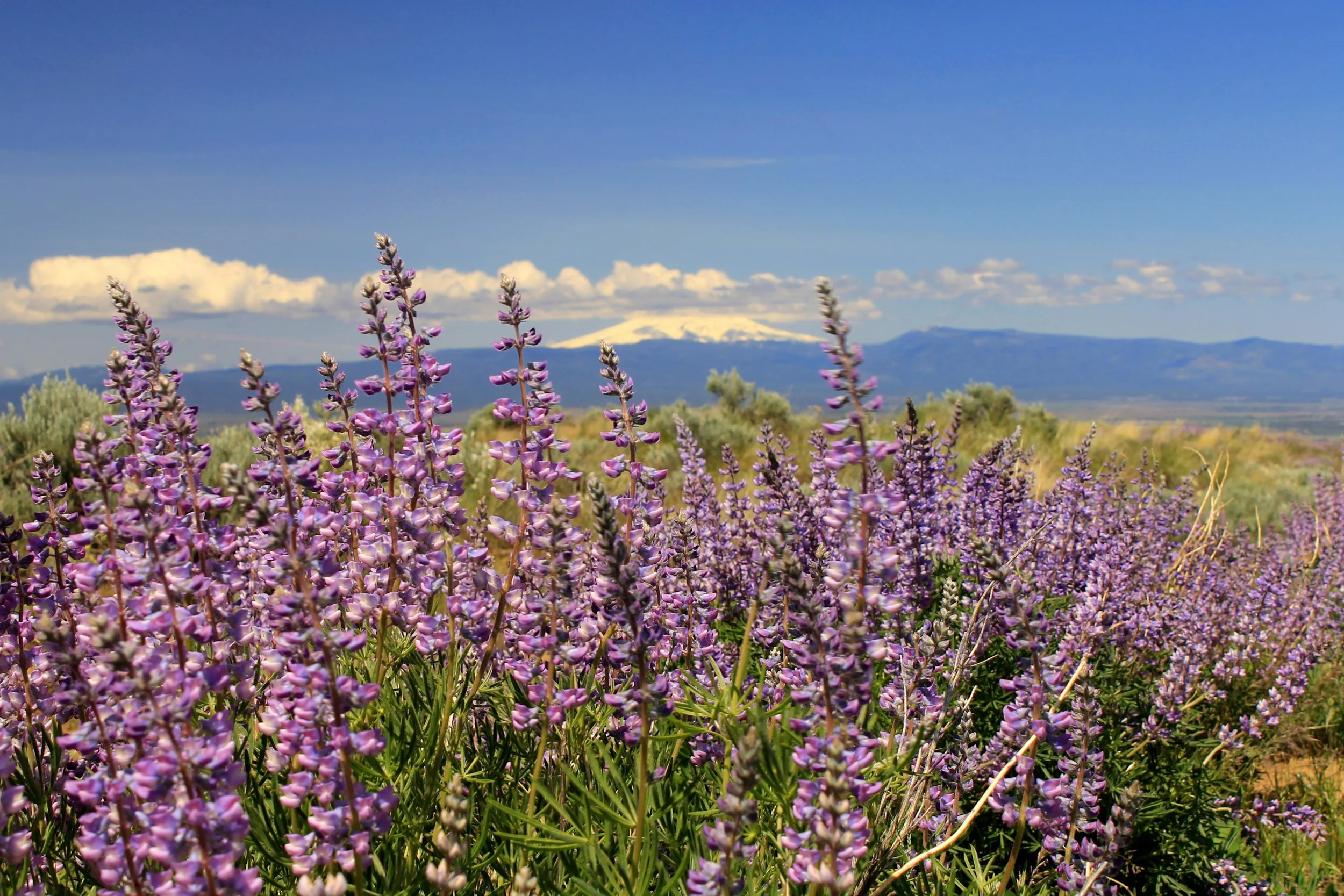
Lupine and Mount Hood at Criterion Ranch, April 2016
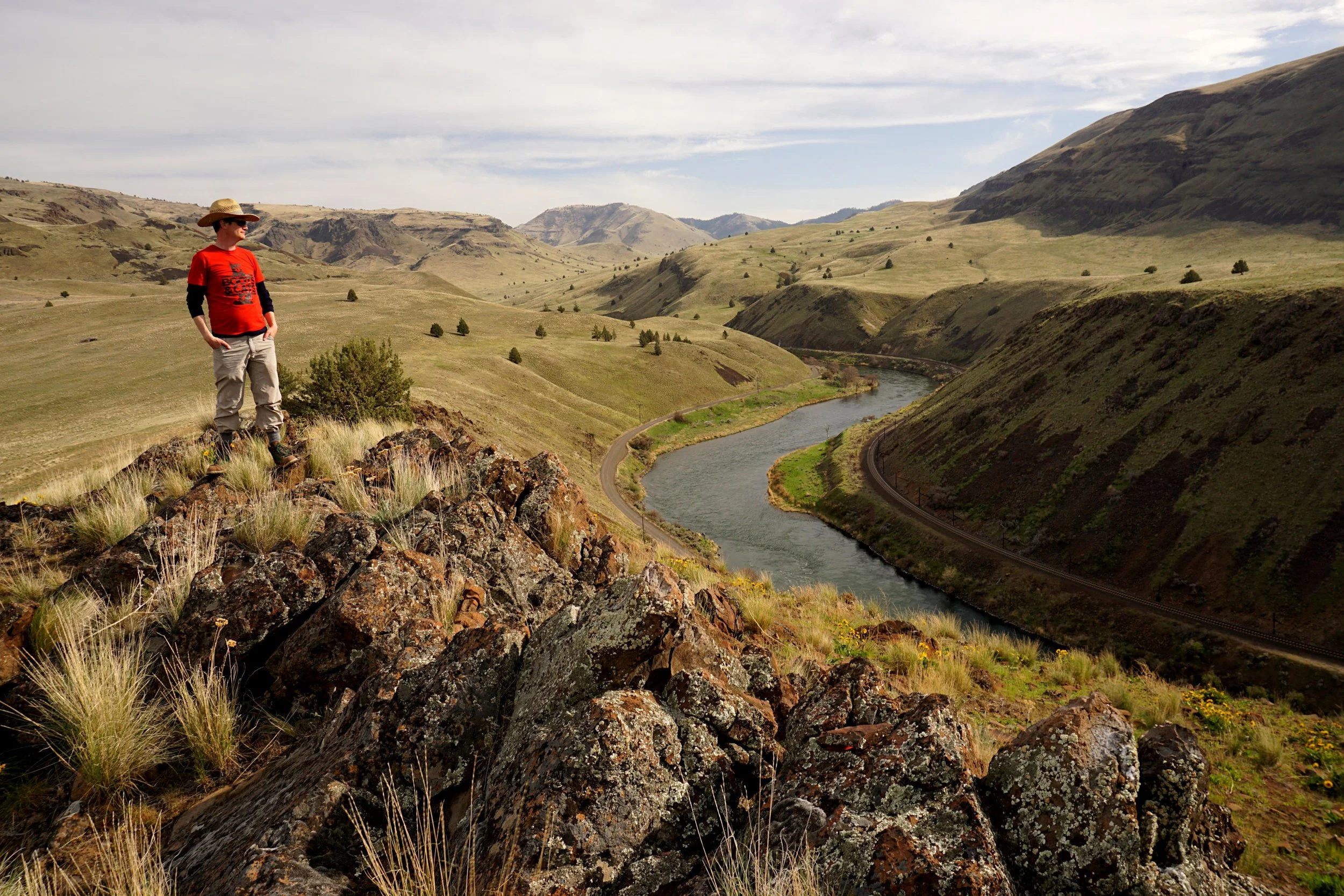
Karl standing above the Deschutes River at Criterion Ranch.
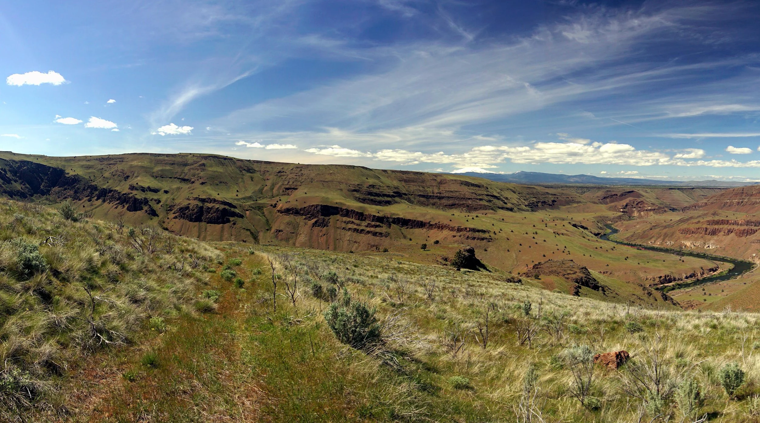
The Deschutes River and Mount Hood are just part of the beauty of Criterion Ranch
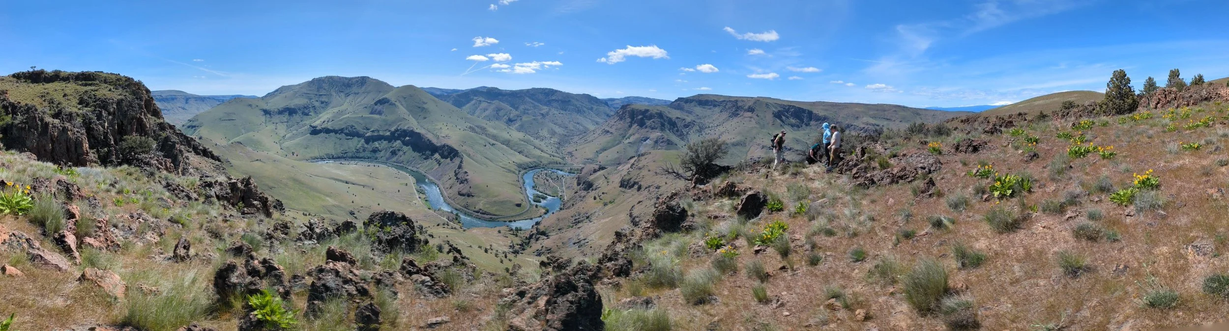
Hike: The Criterion Tract of BLM land south of Maupin is very much a place where you can choose your own adventure. There are many satisfying adventures to be had here, but perhaps the best follows an old ranch road to a viewpoint looking out to Mount Hood and directly down to a scenic bend along the Deschutes River. Hikers comfortable with off-trail travel can continue several more miles to an even more extraordinary viewpoint of the Deschutes River and the hidden peaks of the Warm Springs Reservation. This is a beautiful hike in any season but never more so than in spring, when flowers bloom and the hillsides turn a striking shade of green. Avoid this area in the heat of summer and during cold periods in the winter. There is no shade on this hike, so avoid the area when conditions are unkind.
From the trailhead, ignore the road beyond the gate and instead follow the trail climbing through a gap behind the pit toilet. You will pass a gate and quickly climb onto a meadowed bench above the river. The trail passes through a cattle gate at a half-mile; make sure to close it behind you after you hike through. This entire hike is on public land, but the gates are designed to keep cattle out of certain sections of the area. From here, the trail climbs gradually beneath the rocky ramparts of the Deschutes canyon. Birds of all varieties patrol the skies overhead. As you ascend, look behind you for Mount Hood on the northwestern horizon, towering over the high plains west of Maupin and Tygh Valley. The trail then passes through another fence and continues climbing. At 2.3 miles, the trail passes by a pair of promontories on the right with views down to the river. At the second of these viewpoints, leave the trail and head down to this rocky vantage, where a single juniper stands sentinel above the Deschutes canyon. You will very quickly reach the cliff-edge below the juniper, where the views are eye-popping. The serpentine and deep blue Deschutes River is below you, while Mount Hood looms behind you on the horizon. In an area with many great viewpoints, this is one of the best.
Hikers uncomfortable with off-trail travel should turn around here. Beyond Juniper Point, the trail continues climbing another 1.3 miles to the top of the canyon at 3.6 miles. Keep an eye out for cows along the way, who roam this upper section of the Criterion Tract. When the trail tops out, you will see a fence in front of you; this fence marks the boundary of a section of private land. Leave the trail here and follow the fence steeply downhill to a spring, then uphill over a knoll. When you reach the top of the knoll, you will see Stag Point, your destination, in front of you. Although the way is steep at times, navigating this off-trail section is quite easy. You should meet another dirt road at about 5 miles from the trailhead. Follow the road until you near Stag Point, then set off cross-country to Stag Point itself, marked by a tall post. When you reach the point at 5.8 miles, the view from the slopes down to the river and out to Mount Hood are absolutely incredible, and it can be very difficult to leave. Return the way you came unless you’ve decided to set up a car shuttle to the upper Criterion Trailhead on US 197 (see below).
NOTE:
If you’d like to continue on a loop, you will need a map showing the property boundaries in this area. You can find the property boundaries on both GaiaGPS and CalTopo. You will need this to avoid hiking on private property down towards the Deschutes River. You will also need to hike off-trail down steep open slopes to connect the road to the road that follows the Deschutes River. If you can do this, then this loop is the best way to experience this beautiful area!
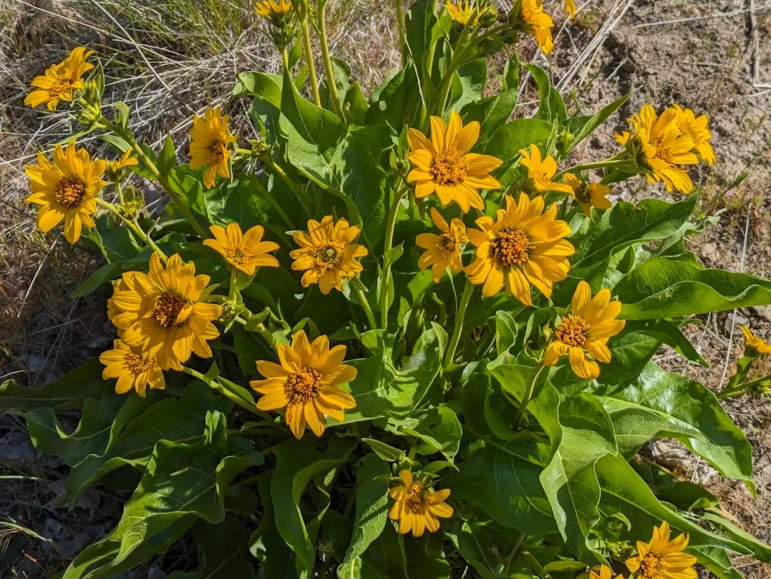
So if you’re continuing, return to the road below Stag Point and follow it downhill towards the Deschutes River. The road switchbacks away from Stag Point and reaches a gate 1.2 miles from Stag Point, or 7 miles into your hike. The gate states that everything beyond this point is private property, but the sign is incorrect: the property boundary is in fact almost a full mile down this road. Continue downhill into this beautiful side canyon full of spring-blooming flowers such as desert parsley, lupine, and balsamroot.
There are two ways down to the Deschutes River from this side canyon. The first is a faint jeep road that departs from the main road after about 0.5 mile. You will see this road cutting away from the main road downhill towards the river. Follow it downhill and angle left towards a bluff above the river. You should pick up a trail leading downhill to the right, which will soon take you to the river just before Buckskin Mary Camp. For the second route down to the river, continue on the road heading downhill in the side canyon. Once you curl around the corner, you are approaching the real property boundary. Bail off the road here at just under 8 miles, or just under a mile from the gate up above. Follow the property line on your map into a small creek bed, then scramble up the other side. Stay above the property line, angling almost due west. You will see a bluff above the Deschutes River, where you will locate a rough trail heading downhill to the Deschutes River. Follow it downhill to the river just above Buckskin Mary Camp.
Once you reach the road along the Deschutes River, follow it a little over 4 miles back to the Locked Gate Trailhead. Along the way, you’ll pass through a series of property boundaries. On public land you are free to wander down to the river and up the slopes to overhangs and viewpoints, but you will need to stay on the road during the stretches of private property. The canyon is absolutely beautiful, and even though you’ll be hiking on a gravel road, you will no doubt appreciate the rest of the experience.
Other hiking options:
If you’re looking to set up a car shuttle, drive south of Maupin on US 197 for 10.9 miles to an obvious trail on the left side of US 197. From here, set out on dirt roads for just over 5 miles to Stag Point. This section of the Criterion Tract is heavily grazed by cattle and is very muddy.
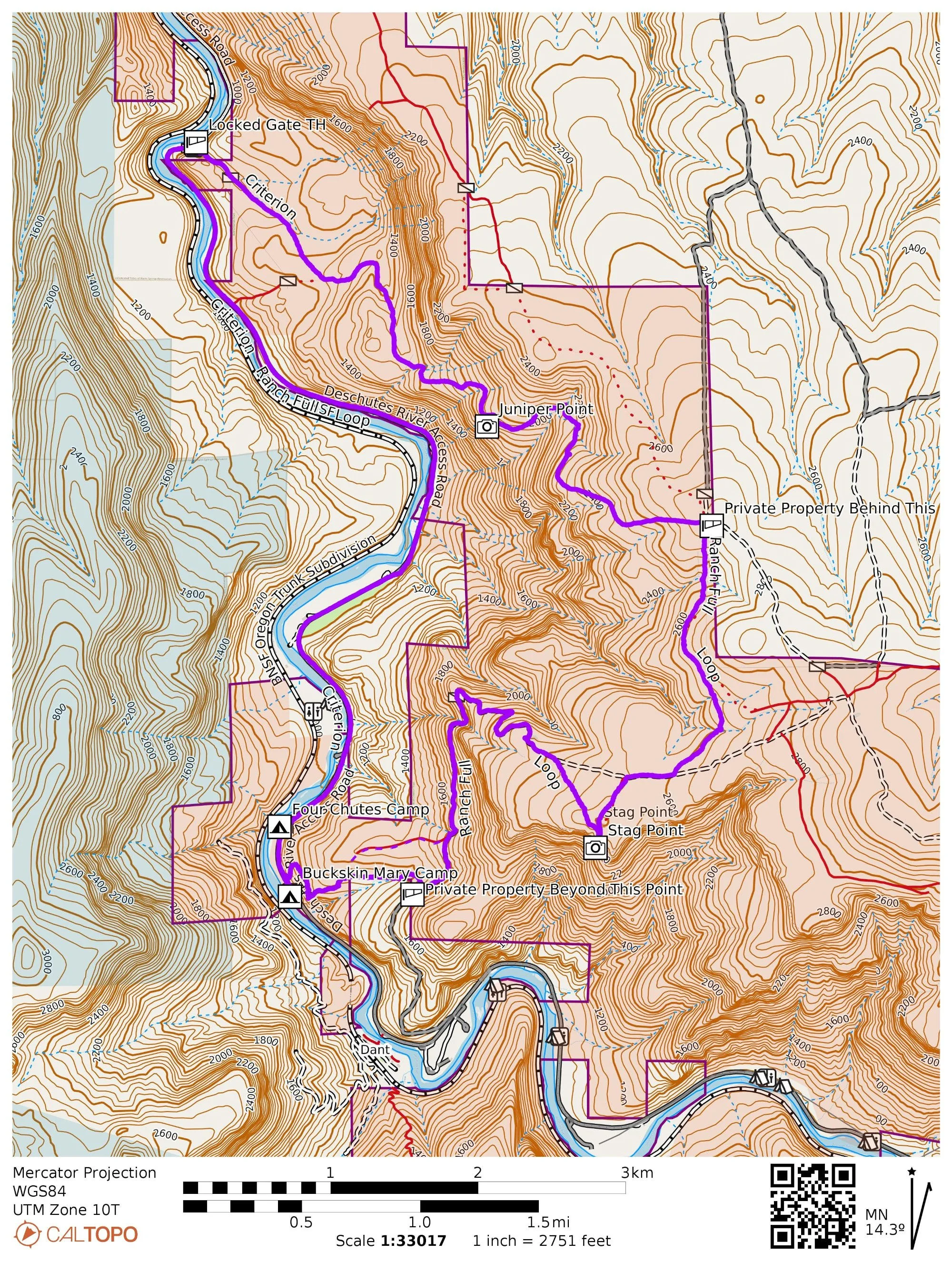
Criterion Ranch Loop. Public land is in orange, private land is in cream and marked by boxes.